DEM → JPEG · Windows

Convert DEM to JPEG

DEM to JPEG offline, so survey, cadastral and client data never goes through an upload form. No file size limit and no per-file quota.

Online converters too slow for your DEM files? reaConverter works locally and handles unlimited batches. All processing runs locally on your PC, so your files stay private and secure. Handles whole folders of tiles and layers in one run, with identical settings on every file.

.dem.JPEG
4.8

Converting files since 2001

Runs offline — nothing uploaded

Read what our users say →

How to Convert Multiple .dem Files to .jpeg?

1. Download and Install reaConverter

First, grab reaConverter from the download button below. Installation is fast, and the software runs offline — no account or signup needed.

2. Load your DEM files

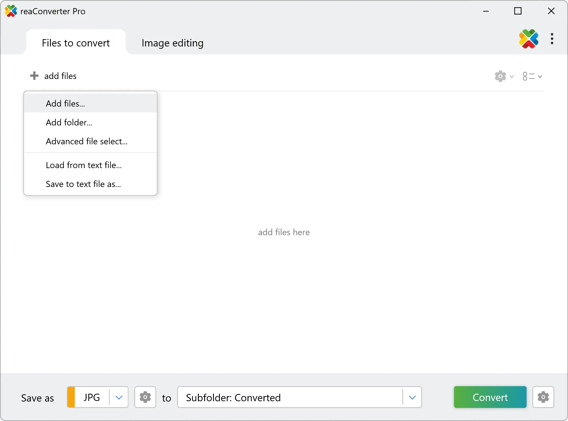
Add DEM files to reaConverter. One file or a thousand, the process is the same. Everything runs locally on your machine.

You can drag-and-drop files, browse to a folder, or add entire directory trees including subfolders.

Load your DEM files into reaConverter

3. Select JPEG as output format

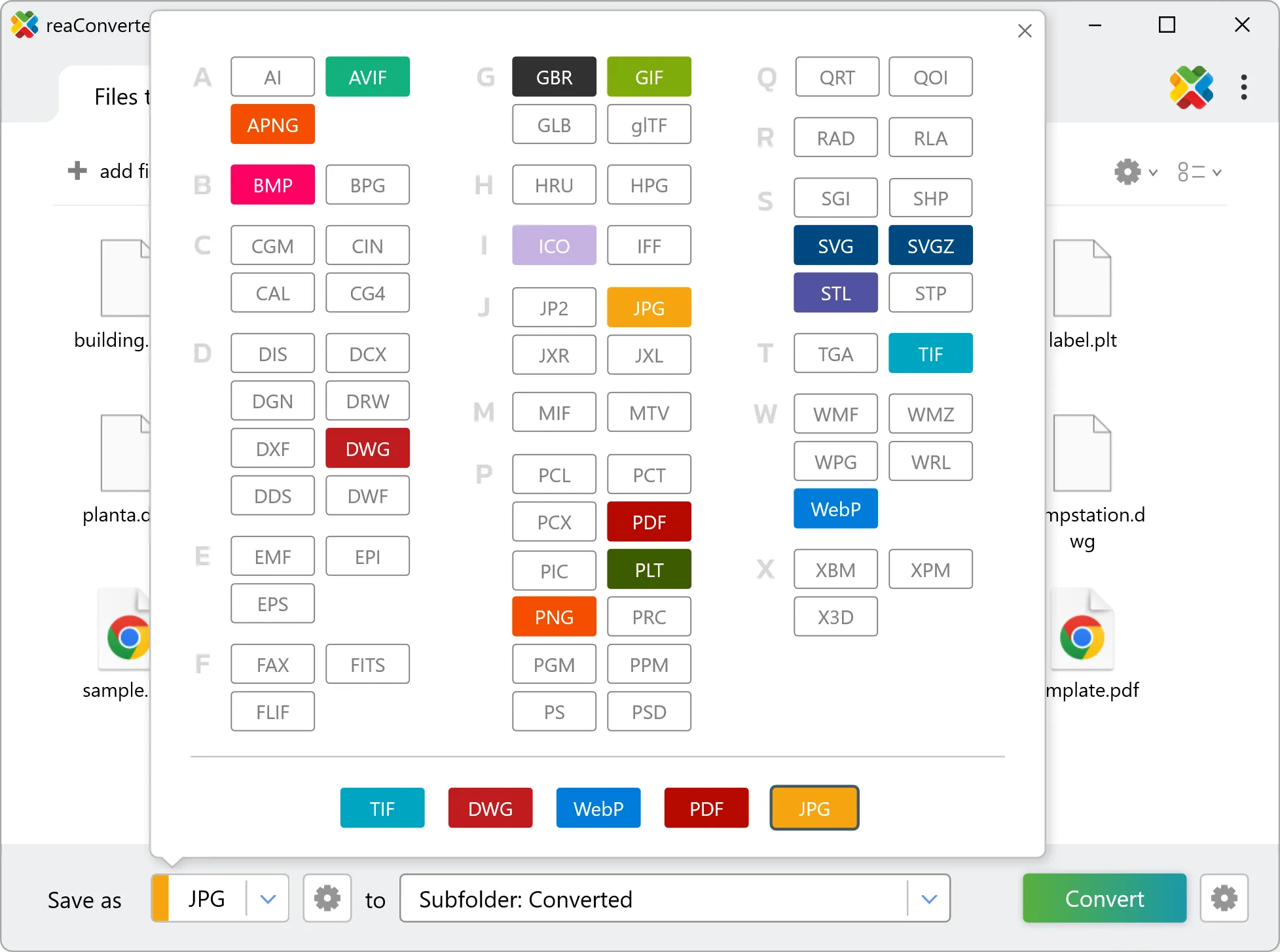
Pick JPEG as the output format. Set the destination folder and optionally configure resolution, quality, or file naming.

Select JPEG as output format

4. Start DEM to JPEG conversion

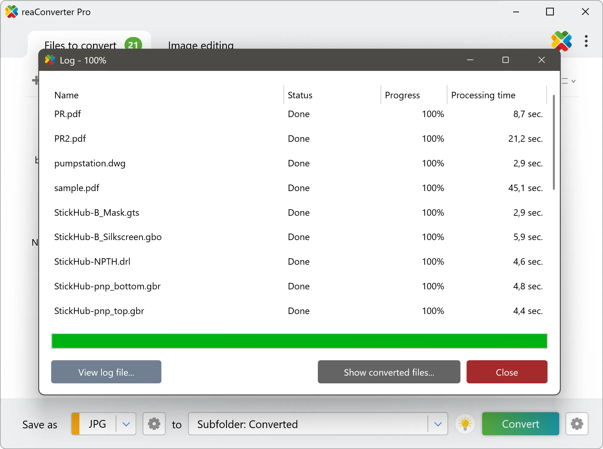
Click the Convert button to start. reaConverter will process all your files with the settings you selected.

Start Conversion

When finished, your new .jpeg files will be waiting in the destination folder.

Step by step

How It Works

reaConverter offers the fastest, simplest solution for converting your DEM files into JPEG without GIS software - all files processed on your PC for maximum privacy and speed.

Technical note

What changes when you convert DEM to JPEG

Every cell in a DEM file holds a measurement rather than a colour, usually elevation in metres, running from sea level up to whatever the highest point in the tile happens to be. JPEG stores brightness, so the conversion stretches that range across a grey or colour scale. What you get is a readable picture of the terrain, and it is the right thing for a relief map or a figure. What you no longer have is the data: sampling a pixel in the JPEG returns a shade, not an altitude. DEM carries georeferencing: a coordinate reference system, and the real-world position and ground size of every pixel. JPEG has nowhere to record any of that. The picture transfers intact, the location does not, so the output cannot be dropped onto a map afterwards without being placed by hand. Keep the DEM original if the data still has to go back into a GIS.

Map Data Workflow

Turn GIS data into something anyone can open

Not everyone who needs to see DEM data has GIS software. reaConverter renders it to JPEG for a report, an email or a slide, and handles a whole folder in one run.

  • Render every file in a folder to JPEG with the same size and settings
  • Set DPI and output dimensions before the run, not afterwards
  • Stamp a text watermark, such as a project name or a date, on every image
  • Pick up new data automatically with Watch Folders, or script the job from the command line

Everything runs on your PC, which matters for cadastral, utility and client data that should not pass through an upload form.

GIS data conversion

User reviews

What people say after the first batch

Average User Rating:4.8
Last updated on September 13, 2026
Creating marketing materials for various platforms requires multiple file versions from single sources. reaConverter's workflow automation lets us generate PNG, JPEG, and SVG variants from AI and PSD files simultaneously. The color profile management ensures brand consistency across all outputs, and the processing speed allows for last-minute changes without delaying deadlines.
Rebecca Turner
Rebecca Turner
Marketing Agency CEO
I was drowning in mismatched file formats until I found reaConverter. The one-click conversion and editing tools simplified everything, and the pricing is reasonable for small businesses. Now I spend less time troubleshooting and more time growing my brand!
Emily K.
Emily K.
E-commerce Entrepreneur
This program is incredibly simple and user-friendly, even beginners can use it with ease. It supports batch processing, works offline, and runs smoothly on my aging Acer Aspire laptop. Best of all, the output quality is outstanding!
Kevin Harris
Kevin Harris
Happy User
Finally an app that actually opens my weird files! Saves me from format frustration daily.
Kyle Brooks
Kyle Brooks
Happy User
This converter delivers exceptionally quick format conversions with reliable results every time.
Brian White
Brian White
Happy User
Security was our top concern when evaluating file conversion tools. reaConverter’s offline mode and role-based access controls let us lock it down for sensitive environments. No unexpected network calls or bloat — just clean, fast conversions. Even passed our pen-testing scans without a hitch.
Marcus White
Marcus White
Healthcare IT

FAQ

DEM to JPEG Conversion

Can reaConverter convert DEM to JPEG?

Yes! reaConverter instantly converts .dem to .jpeg with perfect quality preservation. With its batch processing feature, you can convert multiple files at once in just a few clicks. You can even convert images directly from Windows Explorer using the right-click menu — fast and convenient.

What is reaConverter used for?

reaConverter is a Windows converter for 800+ formats, GIS data among them. For DEM to JPEG it replaces the usual detour through QGIS, ArcGIS or ogr2ogr: add the files, pick the output format, and the whole batch converts offline. Surveyors, planners and engineering teams use it to pass data between GIS, CAD and everyday document formats.

Why choose offline conversion with reaConverter?

reaConverter is a software program that is used for offline files conversion. Your proprietary documents never leave your computer – essential for architects, engineers, healthcare and government contractors handling classified projects. Meets GDPR, HIPAA, CCPA, and corporate security policies by ensuring files never cross borders or third-party systems.

Can I convert DEM to JPEG online?

If you only need to convert a few DEM files to JPEG format, feel free to try our free online free online DEM to JPEG converter — perfect for small batches with no installation needed!

How can I turn DEM files into JPEG on my computer?

The best way to change DEMs to JPEGs on your PC is to install a quality piece of software, such as reaConverter. This software is extremely efficient in managing a wide range of batch files conversions, including conversion from DEM to JPEG.

How can I automate DEM to JPEG files conversion?

reaConverter supports all the most useful automation features such as right-click сonversion and Watch Folders for the most efficient automated files conversion in any software of this type.

Is there a way to convert DEM files to JPEG using the command prompt?

reaConverter provides full access to all its features via Windows command line, including a high-performance command-line dem to jpeg converter for batch processing.

What else can I do with reaConverter?

Convert DICOM filesCrop photoConvert vector filesChange image DPIConvert GIS files

Related conversions

Other ways to convert DEM files, and other sources that convert to JPEG.
Discover More

Beyond format conversion

Batch conversion, editing, and processing across 800+ formats, from RAW and HEIC to DICOM, DWG, and PDF. Everything runs locally, with no cloud and no upload limits.

Free trial · Windows 10/11 · v8.0.250 · Files never leave your computer

reaConverter software