GEOJSONL → TIFF · Windows

Convert GEOJSONL to TIFF

Batch convert GEOJSONL to TIFF on an ordinary Windows PC. No GIS licence, no command line, the same settings applied to every file.

Manual GEOJSONL to TIFF conversion wastes hours. reaConverter automates the process — just add files and click Convert. Everything happens offline on your computer. No uploads, no cloud risks. Survey and cadastral data stays on your machine, with no upload at any point.

.geojsonl.TIFF
4.8

Converting files since 2001

Runs offline — nothing uploaded

Read what our users say →

How to Convert Multiple .geojsonl Layers to .tiff?

1. Download and Install reaConverter

reaConverter is a standalone Windows app — download, install, and start converting GEOJSONL files in under two minutes.

2. Load your GEOJSONL files

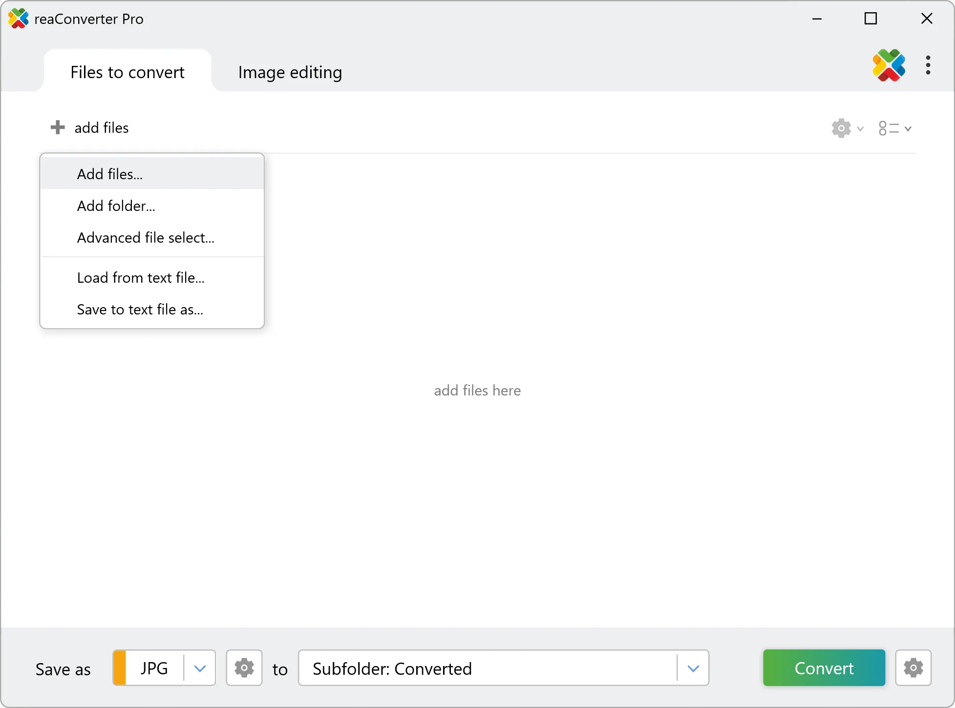
Open reaConverter and add your GEOJSONL files. You can load individual files, entire folders, or even nested subfolders.

Drop your GEOJSONL files into the window or use File menu to browse and select folders.

Load your GEOJSONL files into reaConverter

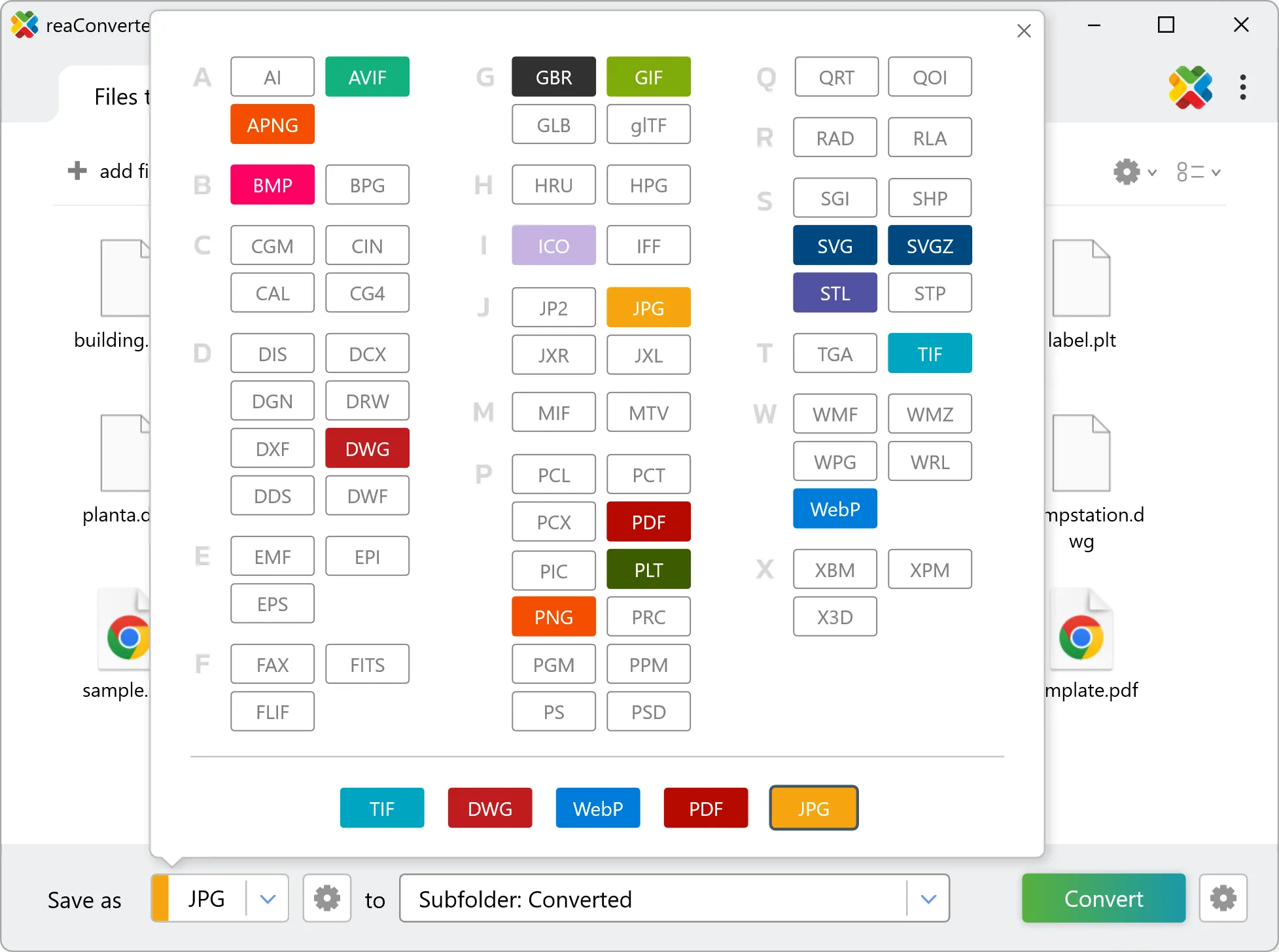
3. Select TIFF as output format

Choose TIFF for output and set your save location. reaConverter lets you customize quality and apply edits before conversion.

Select TIFF as output format

4. Start GEOJSONL to TIFF conversion

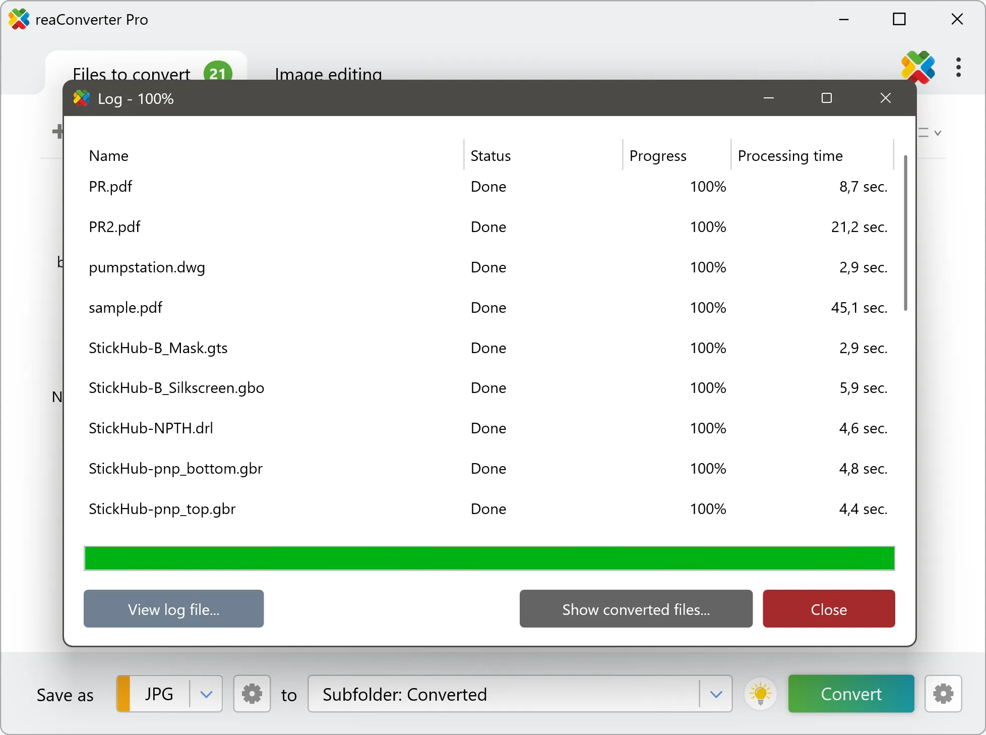
Hit Convert and let reaConverter do the work. The progress window shows status for each file in real time.

Start Conversion

After conversion, find your TIFF files in the output folder. Click 'Show converted files' to open it directly.

Step by step

How It Works

reaConverter offers the fastest, simplest solution for converting your GEOJSONL files into TIFF without GIS software - all files processed on your PC for maximum privacy and speed.

Technical note

GEOJSONL to TIFF: what carries over and what does not

A GEOJSONL file holds geometry and an attribute table, and nothing at all about appearance. Colours, line weights, fills and labels are properties of the GIS project rather than of the file, which is why the same GEOJSONL looks different in every program that opens it. The TIFF render therefore falls back on defaults and will not match the styled map you see in QGIS or ArcGIS. Expect a clean drawing of the geometry rather than a finished cartographic product. GEOJSONL describes geometry rather than pixels, so it has no inherent resolution. The conversion renders it at whatever size you choose, and that choice is final: enlarging the TIFF afterwards will not recover the sharpness. Set the output dimensions or DPI before converting, not after.

Map Data Workflow

Turn GIS data into something anyone can open

A map saved as TIFF opens on any computer and any phone. reaConverter produces those from GEOJSONL in batch, entirely offline.

  • Render every file in a folder to TIFF with the same size and settings
  • Set DPI and output dimensions before the run, not afterwards
  • Stamp a text watermark, such as a project name or a date, on every image
  • Pick up new data automatically with Watch Folders, or script the job from the command line

Everything runs on your PC, which matters for cadastral, utility and client data that should not pass through an upload form.

GIS data conversion

User reviews

What people say after the first batch

Average User Rating:4.8
Last updated on September 13, 2026
As a book scanner, I deal with TIFF files daily – they're huge. reaConverter compresses them to PDF or JPEG without losing any detail. I've saved terabytes of storage and still have archive‑quality images. This software paid for itself in storage costs alone.
Edward N.
Edward N.
Digitization Specialist
I'm a graphic designer, and I often receive TIFF files from photographers. reaConverter converts them to editable PSDs with layers intact (where possible). It even keeps the colour profiles. This has streamlined my collaboration with clients tremendously.
Benjamin F.
Benjamin F.
Creative Director
I work in medical imaging, and we receive TIFFs from various sources. reaConverter converts them to DICOM‑compatible formats while preserving all pixel data. It's HIPAA‑friendly because it works offline – no data leaves our network. Essential for our lab.
Dr. Harold Kim
Dr. Harold Kim
Radiology IT
I needed to convert TIFF to multi‑page PDF for an archive project. reaConverter handled it effortlessly – 2,000 pages in one batch. The output PDF was searchable (thanks to OCR) and had the same resolution as the originals. Absolutely brilliant.
Patricia O'Brien
Patricia O'Brien
Satisfied Customer
For quick TIFF to JPG conversions without installations, this online tool outperformed 5+ competitors I tested. The streamlined interface delivered ready-to-use JPEGs in under 30 seconds per batch.
Paul Thomas
Paul Thomas
Happy Online User
My scanning software outputs TIFF, but I need PNGs for my website. reaConverter batch‑converts hundreds of TIFFs to PNG with perfect colour fidelity. The process is lightning‑fast, and the interface is so intuitive that even my non‑tech assistant uses it.
Maria Santos
Maria Santos
Satisfied Customer

FAQ

GEOJSONL to TIFF Conversion

Can reaConverter convert GEOJSONL to TIFF?

Yes! reaConverter instantly converts .geojsonl to .tiff with perfect quality preservation. With its batch processing feature, you can convert multiple files at once in just a few clicks. You can even convert images directly from Windows Explorer using the right-click menu — fast and convenient.

What is reaConverter used for?

reaConverter is a Windows converter for 800+ formats, GIS data among them. For GEOJSONL to TIFF it replaces the usual detour through QGIS, ArcGIS or ogr2ogr: add the files, pick the output format, and the whole batch converts offline. Surveyors, planners and engineering teams use it to pass data between GIS, CAD and everyday document formats.

Why choose offline conversion with reaConverter?

reaConverter is a software program that is used for offline files conversion. Your proprietary documents never leave your computer – essential for architects, engineers, healthcare and government contractors handling classified projects. Meets GDPR, HIPAA, CCPA, and corporate security policies by ensuring files never cross borders or third-party systems.

Can I convert GEOJSONL to TIFF online?

If you only need to convert a few GEOJSONL files to TIFF format, feel free to try our free online free online GEOJSONL to TIFF converter — perfect for small batches with no installation needed!

How can I turn GEOJSONL files into TIFF on my computer?

The best way to change GEOJSONLs to TIFFs on your PC is to install a quality piece of software, such as reaConverter. This software is extremely efficient in managing a wide range of batch files conversions, including conversion from GEOJSONL to TIFF.

How can I automate GEOJSONL to TIFF files conversion?

reaConverter supports all the most useful automation features such as right-click сonversion and Watch Folders for the most efficient automated files conversion in any software of this type.

Is there a way to convert GEOJSONL files to TIFF using the command prompt?

reaConverter provides full access to all its features via Windows command line, including a high-performance command-line geojsonl to tiff converter for batch processing.

What else can I do with reaConverter?

Convert vector filesChange image DPIConvert whole-slide imagesResize photoConvert PDF files

Related conversions

Other ways to convert GEOJSONL files, and other sources that convert to TIFF.
Discover More

Beyond format conversion

Batch conversion, editing, and processing across 800+ formats, from RAW and HEIC to DICOM, DWG, and PDF. Everything runs locally, with no cloud and no upload limits.

Free trial · Windows 10/11 · v8.0.250 · Files never leave your computer

reaConverter software